

Cell service decides more about a wedding arrival than most couples realize. When a venue has weak or no cell service, a guest’s phone map stalls, the rideshare app stops updating and the “we’re lost, where are you?” text never sends. This guide shows how to find the cell service dead zones, write directions that work without cell service, and build a printed fallback that gets every guest to the right door.
Drive or walk the whole route to your venue with two or three phones on different carriers and note where cell service drops. Mark the last spot where service is dependable. From that point to the ceremony seat, give guests directions that need no cell service: a short written final-mile card, a pre-downloaded offline map, a printed copy in the car or hotel bag, and a person or sign at every fork. Then decide who can be reached by landline or radio on the day, since texting will not be reliable.
Most wedding directions are written for a world where the phone always works and cell service is a given. The invitation website has an address, the address opens a map app, and the app talks guests down the road. That chain breaks at the first stretch without cell service, and the break usually lands exactly where the road gets confusing: a gravel turnoff, a gated entrance, a second parking field, a service road that looks like the main one.
This article is about that gap. It is not a general guide to signs, and it is not a full plan for wedding day communication. It covers one narrow job: getting guests to the right place when cell service is unreliable, and keeping the couple, the venue and the vendors in touch when it is. If you want the wider picture of how people move through a reception, the guide to reception guest flow covers entry, seating, food and exit once guests are inside.
A note on scope. This is general information, not legal, safety or engineering advice. Cell coverage, road rules, emergency procedures and venue policies differ by place and change over time, so the article points you to the people and agencies who can confirm the current facts for your site.
Why cell service fails at wedding venues
Venues that people love for weddings are often the venues that phones dislike. The reasons are mostly physical, and understanding them helps you predict where trouble will be before you test anything.
Distance from towers. A vineyard, a ranch, a lakeside lodge or a mountain camp may sit many miles from the nearest tower. Signal strength falls with distance, and a phone that shows one bar may still be unable to load a map tile.
Terrain. Hills, ridges, valleys and dense tree cover block or weaken radio signals. A site can have good cell service on the hilltop and none in the hollow where the ceremony lawn sits, a few hundred yards away.
Building materials. Thick stone, brick, metal roofing, low-emissivity glass and old plaster all reduce signal indoors. A historic hall or a converted barn with a metal roof can be a cell service dead zone inside while the parking lot works fine.
Crowds. A venue with two hundred guests puts a lot of phones on one nearby tower. Even where coverage is decent on a quiet weekday, congestion can slow data to a crawl during the reception, which matters for photo uploads and ride requests at the end of the night.
Carrier differences. Two guests standing side by side can have different results. One carrier may have a tower near the site and another may not. A test with a single phone tells you about one carrier, not about the room.
Roaming and plans. Guests flying in from abroad, or using a prepaid plan, may have little or no data outside a home region. They may rely entirely on hotel Wi-Fi, which stops at the hotel door.
The Federal Communications Commission publishes a National Broadband Map that shows reported mobile coverage by provider. It is a useful first look, but it reflects provider-reported data and general modeling, so treat it as a starting guess and confirm with a test on the ground. The next section explains why.
A map is not a test
A coverage map shows what a provider says is likely. It cannot see the shed that blocks the signal at your gate, or the ridge between the parking field and the lawn. Many couples look at a map, see colored coverage, and stop. Use the map to decide how worried to be, then do the real test described in the survey section.
GPS is not the same as cell service
This distinction trips up almost everyone. A phone’s location dot comes from satellite positioning, which does not need cell service. The map underneath it does need data unless it has been downloaded in advance. So a guest in a cell service dead zone often sees their blue dot floating on a blank gray screen. They know where they are and have no idea where to go. Offline maps solve exactly that problem, and a later section explains how guests can prepare.
What breaks when guests lose cell service
Before designing a fix, list what actually depends on a connection during a wedding arrival. The list is longer than most couples expect, and each item has its own workaround.
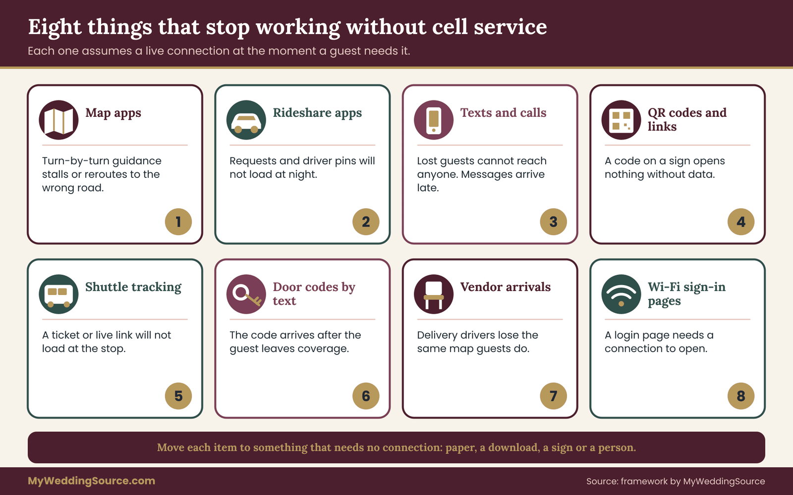
Map apps and live navigation. Turn-by-turn directions usually need data. If the signal drops mid-route, the app may keep the planned route for a while and then lose the thread, or it may reroute to the wrong road.
Rideshare apps. Requesting, tracking and meeting a driver all need data. A guest who walks out of the venue at night with no cell service cannot book a ride, and a driver cannot find a pickup pin that has not loaded.
Texts and calls to the couple or the planner. Guests who are lost will text the couple first, which is the worst possible target on the wedding day. If the signal is poor, those messages queue and arrive late, if at all.
Digital invitations and QR codes. A QR code on a sign that links to a web page will not open without data. A wedding website with the directions on it is invisible to a guest who needs it most, at the turnoff.
Parking and shuttle apps. Event shuttles that rely on a live tracking link or a ticket on a phone create a quiet failure: the guest stands at the stop with a screen that will not load.
Hotel and venue digital keys, door codes and Wi-Fi sign-in pages. If your plan has guests collecting a code by text at the gate, it will fail where the cell service fails.
Vendor coordination. Caterers, florists, bands and delivery drivers often find the venue through the same map apps. Late deliveries on a rural road are a common result of a weak signal, which is why vendor arrival directions matter as much as guest directions. The guide to the venue technical walkthrough covers access routes and loading details from the vendor side.
Notice what the list has in common. Each item assumes a live connection at the moment of need. The fix, in every case, is to move the information to a place that does not need the connection: paper, a downloaded file, a person, or a sign.
The guest’s real problem is a decision, not a map
A guest at a fork does not need a whole map. They need to know which of two or three options to take, now, with no cell service. This is the idea that drives the rest of the guide. Directions for a cell service dead zone should be built around decisions: where you will have to choose, what you will see there, and which choice is right. Anything else is decoration.
The signal walk: survey the route before you write a word
Cell service is invisible, so the central tool in this guide is a simple field survey, which we will call the signal walk. It takes one afternoon, ideally on a day and time similar to the wedding. Its goal is to produce two things: a picture of where cell service holds and where it fails along every route guests will use, and one fixed point on each route called the last good signal point.
The last good signal point is the final spot, before the venue, where a typical phone still has dependable service. Everything before that point can rely on normal apps. Everything after it needs directions that work without a connection. Once you know where that point is, the planning gets much easier, because you know exactly how long the offline stretch is and how many decisions fall inside it.
Who and what to bring
Take at least two people and, if you can, three phones on different carriers. Include one phone that is a few years old, since guests will carry all ages of device. Bring a notebook or a printed sketch of the route, a pen, and a way to measure distance: the car odometer works well, and a pedometer or a step count works on foot.
If you have a planner or venue coordinator, ask whether they already know the cell service dead zones. They often do, and they may know which carrier works best on the property. Treat that as a lead, not a result, and still walk it yourself.
If the venue is far from where you live, ask the venue manager or a trusted vendor to do the walk and send you notes and photographs. A couple who cannot be present can still get a reliable survey from someone who follows the same method.
Choose the legs
Break the guest journey into legs, because the answer for each leg may differ. For most weddings the legs are:
- The approach road, from the highway or the last town to the venue turnoff.
- The entrance, from the turnoff to the gate or driveway, including any gate, cattle guard, ticket booth or security check.
- Parking, from the gate to the parking area, including any overflow field or shuttle stop.
- The walk, from parking to the check-in point, the ceremony site and then the reception space.
- The return, from the reception back to the parking area or pickup point, in the dark.
Add a leg for any second location, such as a hotel, a rehearsal dinner site or an after-party. The route between two locations is its own survey.
Rate each leg with three simple colors
At every notable point on each leg, check each phone and write down what it can do, not just how many bars it shows. Bars are unreliable. Use a simple three-color rating:
Green: the phone loads a map tile, sends a text and places a short call without delay.
Amber: the phone sometimes works, but loading is slow, texts take a long time or a call drops. Guests will be frustrated but may get through.
Red: the phone cannot load a map, send a message or hold a call. Treat this as no cell service at all.
Test the same things at each point so results compare fairly. A good routine is to open a map and pan to a spot you have not viewed, send a short text to someone with a signal, and try a call or a Wi-Fi call if you plan to use it. Write the result for each phone. Where the three phones disagree, mark the point amber and note which carrier worked.
Mark the decision points on the same sketch
While you walk, mark every spot where a stranger would have to choose or might hesitate: a fork, a turn, a gate that could be mistaken for the entrance, an unmarked driveway, a parking choice, a path that splits. These are the same decision points that appear in signage planning. The guide on wedding signage as a system explains how to place signs at them. Here the point is narrower: a decision point that sits in a red leg is a high-risk spot, because the guest cannot check a map and cannot call anyone.
For each risky decision point, write down three things: what the guest sees there (a landmark, a mailbox number, a sign for another business), the correct choice, and the most likely wrong choice. That last item matters. Most wrong turns have a favorite wrong destination, such as the farm stand next door, the public boat ramp or the service entrance, and your directions should name it so guests recognize their mistake early.
Find the last good signal point
Now look at your sketch. Starting from the venue and working backward along the approach road, find the first point where all your test phones show green or at least dependable amber. That is the last good signal point for that route. Mark it with a landmark that a driver can identify without a map: a gas station, a road sign, a bridge, a crossroads, a named intersection.
Pick a point you can name in a sentence. “The gas station at the intersection of the county road and the state highway” works. “About eleven miles back, near a bend” does not.
Record the distance and the typical drive time from the last good signal point to the venue gate. If it is two minutes, the offline stretch is trivial and a short card will do. If it is twenty minutes on winding roads with several turns, your directions must be much more careful, and you should consider staffing a fork or pairing guests with a shuttle.
Repeat the cell service test at the time of day that matters
Signal can change between a quiet weekday afternoon and a crowded Saturday evening. If possible, repeat the check at the hour guests will arrive, and again at the end of the night. Congestion tends to slow data, not remove it, which usually shifts an amber point toward red. Light, weather and leaf cover also change conditions. If you cannot repeat the walk, add a margin: assume that anything amber on your test will be closer to red when guests arrive.
Test cell service on the return trip separately
Couples often survey cell service only on the arrival. The return trip has different problems. Guests are leaving in the dark, some will have had a few drinks and will use a rideshare, and everyone leaves at about the same time. Check cell service at the pickup point and in the parking area, and test whether a rideshare request can load there. If it cannot, the plan needs a pickup spot that does work, or a pre-booked car service, which is covered in a later section.

Record results in a one-page survey sheet
Keep the survey on a single sheet so it can be handed to a planner, a coordinator or a vendor. A useful sheet has the route sketch, the color rating for each leg, the last good signal point with its landmark, the distance and time from that point to the gate, the decision points with the correct and likely wrong choice, and the name of whoever did the walk and the date. You will use this sheet in nearly every later step, from writing the directions card to briefing the staff.
What the survey tells you about the plan
Read the finished cell service sheet as a decision guide. It will usually fall into one of three patterns, and each suggests a different amount of effort.
Pattern one: green almost everywhere, a short red patch near the lawn. The offline stretch is only a short walk. A sign or two and a mention on the day-of card are enough. Do not over-engineer it.
Pattern two: amber on the approach road, red from the turnoff onward. This is the common rural pattern. Guests will lose their map a few minutes before the gate. A downloaded offline map, a final-mile card and a person at the turnoff solve most of it.
Pattern three: red or unreliable most of the way from the last town. The offline stretch is long. Treat it as a trip that must be planned like a short expedition: pre-downloaded maps for everyone who can manage it, a printed card mailed with the invitation, a convoy or shuttle option, and a second person on a different route as backup. The couple should also discuss, honestly, whether the date and time make sense for guests who are older or driving a long way after dark.
Weak cell service is not a reason to avoid a beautiful venue. Plenty of memorable weddings happen in places with no cell service. It is a reason to spend your effort where the lack of cell service actually hurts.
Check coverage for the staff and vendors, too
The people who run your wedding also need to reach each other. During the survey, test the places where staff will stand: the kitchen, the ceremony site, the band area, the check-in table and the parking attendant’s post. If your photographer, caterer and coordinator cannot text each other from their working positions, the problem is bigger than guest directions. Ask the venue what they use on site.
Many remote venues rely on radios, a landline or a venue Wi-Fi network. The guide on wedding day digital operations covers backup communication in depth, and a later section here gives a simple contact ladder for the specific case of missing cell service.
What to ask the venue before you walk
A short phone call before the survey saves time. Ask the venue manager these questions in plain language:
- Is there guest Wi-Fi, and where does it reach? Does it cover the ceremony site, the parking area and the reception?
- Which carriers work best on the property, and where are the known dead spots?
- Is there a landline, and who answers it on the wedding day?
- Do vendors and staff use radios, and can you borrow or rent some?
- Is there a gate, a code or a check-in point where guests will be stopped, and who staffs it?
- Does the venue have its own printed directions or a recommended route? Some venues have learned from experience that map apps send visitors to the wrong gate, and they keep a standard instruction sheet.
Write down the answers on the survey sheet. If the venue is vague or has never thought about it, that is useful information as well, and it tells you how much of the plan will be yours to build.
Write final-mile directions that work without cell service
Now turn the cell service survey into words. The final-mile card is a short written set of directions that begins at the last good signal point and ends at the place where a guest parks or checks in. It is the single most useful object in a venue with poor cell service, because it works on paper, in a screenshot, in a text message that was sent days earlier, and in the mouth of a staff member at a gate.
The card has one job: get a stranger from a named landmark to the right door, in the dark if necessary, with no cell service, no map and no one to ask. Write it with that guest in mind.
Start from the landmark, not from home
Directions that begin at “your house” are useless to a guest who is already on the road. Begin where the survey told you service ends, and name that spot plainly. “When you pass the gas station at the junction of the county road and the state highway, cell service becomes unreliable. From here, follow these steps.” That single sentence tells the guest why the card exists and when to start using it.
Use landmarks, distances and counts together
A direction like “turn left at the red barn” fails at night, after a storm, or when the barn is painted over. A direction like “go 3.2 miles” fails if the guest’s odometer is off. Use both, and add a count where possible, so a guest can cross-check.
Compare two versions of the same step:
Weak: “Turn onto the gravel road by the old barn.”
Stronger: “After about 3 miles, just past the second bridge, turn left onto the gravel road with the green mailbox marked 1140. If you reach a fruit stand on the right, you have gone too far.”
The stronger version has a distance, a landmark that is hard to miss, a number to confirm the turn, and a named wrong result. Those four things carry a lot of weight when no one can call for help.
Rules for writing each step
- One action per step. “Turn left” is a step. “Turn left and then continue until the road bends and take the second driveway” is three steps.
- Name the road by what the guest will see. Signs, not route numbers, are what drivers read. Use the exact wording that appears on the street sign or the mailbox.
- Give the compass direction when useful. “Turn left (west)” helps a guest whose phone compass is working and who has lost the map.
- Mention the confirming sign. After each turn, say what the guest should see in the next minute, such as a cattle guard or a stone wall, so they know they chose correctly.
- Name the wrong turn. This is the step that most direction writers skip. “If you see the boat ramp, turn around and go back a quarter mile” saves guests a lot of confusion.
- Keep each step short enough to read at a glance. A passenger will be reading this in a moving car. Ten words per step is a good target.
- End with the landmark that means you have arrived. “You will see a white tent on the right, and a person in a yellow vest.” Include what to do next: where to park and where to walk.
Include the address in two forms, and say which to trust
Venues with poor cell service often have address problems. Rural addresses can resolve to the wrong spot on a map, and a venue with several gates may have a mailing address that is not the guest entrance. If you know that the address shown by common map apps puts guests at the wrong gate, say so plainly on the card: “If your map shows the entrance at the north road, do not use it. Use the east gate described below.”
Add the latitude and longitude as plain numbers if the venue has no clear street address. A phone can enter them in a search box before the trip and save the pin. Do this only where the venue confirms the coordinates match the guest entrance, since a coordinate for the building center may lead to a locked service area.
Keep a landmark table in your head, not on the page
You will be tempted to list every sign, turn and landmark in a long list. Resist. A card with twelve steps and a map becomes a document guests will not read. A useful target is five to eight steps, because each step is a decision point. If your survey found more, look at which steps can be folded together or replaced by a person or a sign, and keep the card for the ones that cannot.
Add a night version for the stretch without cell service
Landmarks that work in daylight may vanish after dark. If any part of the route will be traveled after sunset, reread the card as if it were dark. Replace “the red barn” with something that has light: a lit mailbox, a reflective sign, a gate with solar lights, a road sign that is large and reflective. If the venue will place lanterns or lights, name them. If your survey was in daylight, ask someone to drive the route after dark once, since it can feel like a different place. Many couples are surprised at how hard it is to see a driveway that was obvious at noon.
Test the card with a stranger
Give the draft card to someone who has never been to the venue, and ask them to follow it using only the card, with their phone’s map turned off. Ride along, say nothing, and note every hesitation. Where they slow down, the card needs work. Where they take a wrong turn, add the wrong-turn warning. Two rounds of this usually produce a card that works for nearly everyone. It is the same idea as walking the signs, applied to paper.
A sample final-mile card
The following is invented, for a fictional hillside venue, to show how the pieces fit. Do not copy the details; build your own from your survey.
Last good signal: the gas station at County Road 12 and Highway 40. Cell service becomes unreliable after this point. Follow these steps. Drive time from here: about 14 minutes.
- Turn right (north) on County Road 12. Reset your trip meter.
- At 4.1 miles, after the second bridge, turn left onto Hollis Lane. The corner has a stone wall and a green sign. If you reach a fruit stand, turn around.
- Stay on Hollis Lane past two driveways on the left. The road becomes gravel.
- At 6.0 miles, the gate with the wooden sign “Larkspur Hill” is on the right. Gate is open from 3:00 p.m.
- Follow the cars to the top field and park where staff in yellow vests direct you. Shuttle carts take guests up to the lawn.
- If you are lost, do not turn around alone: call the venue landline at the number printed below, which is answered all afternoon.
Notice the last step. A direction card should always say what to do when the directions fail.
Offline maps for a venue with no cell service: what guests can do before they leave
The card handles the last stretch. The second layer is a map that the guest’s phone can use without data. Both major phone map apps allow areas to be downloaded in advance. The current steps differ by app and by version, so link guests to the official instructions rather than writing your own: Google publishes instructions for offline maps in Google Maps, and Apple publishes instructions for downloading maps for offline use in Apple Maps on supported devices. Both are listed in the sources.
What offline maps do and do not do
An offline map lets a phone show roads, place names and the blue location dot with no data. Depending on the app and the platform, it may also provide route guidance. It does not show live traffic, and it may not offer every feature. Smaller private roads, new driveways and gravel lanes may not appear or may be named differently. So an offline map is a good second layer, never a replacement for the card.
Ask guests to do it early
The step has to happen while the guest still has a signal and Wi-Fi, so ask for it in advance. A good time is when the guest is already thinking about the trip: the week before, in the logistics message. Tell them to download the area for offline use, open the venue pin, and save it. Tell them it takes a few minutes on Wi-Fi and uses storage. Add a plain reassurance for guests who are not comfortable with this: the printed card will also work.
Saved pins and shared locations
A saved pin is a location the guest stores in the map app before the trip. If you share one, test it. Open the pin on a clean phone and check that it lands at the guest entrance and not at the building center or the mailing address. Include the pin as a link in the guest message, along with the plain-text name of the place and the card. If the link fails, the guest still has the name to search and the text on the card.
The weak spots of offline maps when cell service is gone
Be honest about what can go wrong, so you do not rely too heavily on the layer:
- Guests with older phones or little storage may be unable to download a large area.
- Rental cars and car navigation systems often use their own maps and cannot see the guest’s downloaded area.
- Some guests will forget. Even a well-written reminder reaches only part of the group.
- Downloaded maps may expire or need to be updated, so a map downloaded months in advance may be out of date.
- Offline route guidance may choose a road that is closed, steep or not suitable for a low car. Tell guests which road you want them to use, and ask them to follow the card where it differs from the app.
None of these is a reason to skip the step. They are the reason the plan has more than one layer. The three-layer plan described in the next section makes sure a failure at one level does not leave a guest stranded.
Screenshots as a simple fallback
A screenshot of the route or of the directions card is the easiest offline tool of all. It works on any phone, takes seconds and needs no app. Encourage guests to screenshot the card from the guest message or the wedding website, save it to their photos and, if they like, mark it as a favorite. Mention that a screenshot of the venue’s own site, showing the entrance and parking, is also useful. Make the screenshot easy by sending the card as a plain image with large type, not as a long web page that scrolls.
The printed fallback: paper that works when cell service does not
Paper is old technology, and for a wedding with unreliable cell service it is the most dependable layer you have. It does not run out of battery, it does not need a download, and it can be read by a guest who has never opened a map app. The printed fallback is a small set of paper items placed where guests will actually find them, in the order guests will need them.
Treat the printed layer for your cell service problem as a system, not a single sheet. Different guests meet the plan at different moments, and each moment needs its own piece of paper.
The four places paper should live
In the invitation suite or a separate insert. If your venue has weak cell service, put the final-mile card in the invitation envelope or in the details insert, so a guest who opens the mail has the directions in hand weeks before the trip. The guide to wedding invitation etiquette explains what belongs in the main invitation and what belongs in an insert, which keeps the main card uncluttered.
In the hotel welcome bag or at the front desk. Guests staying at a hotel often leave for the venue as a group or in several cars. A card in the room or at the desk catches people who never read the email. Ask the hotel whether the desk staff can keep a stack, and whether the card can be printed on the hotel’s own letterhead, which hotels sometimes prefer.
At the shuttle stop or the last good signal point. If you run a shuttle, give the driver a printed copy of the route and the venue entrance, along with the venue landline number. A driver in a cell service dead zone has the same problem as a guest.
On the day, in a small pocket-sized form. A few extra copies at the check-in table or the parking attendant’s post cover guests who arrive without the card, and a card that guests can take home covers the return trip.
Make the card readable under bad conditions
Guests will read it in a car, at night, on a bumpy road, without glasses. Design for that:
- Use large type. Aim for a size that can be read at arm’s length in dim light. Body text smaller than a normal paperback is too small.
- Choose high contrast. Dark text on a light background, matte paper rather than glossy, which reflects dashboard and phone light.
- Put the landmark and the distance at the start of each line, since a driver glances at the first words.
- Number the steps, and leave white space between them.
- Use a simple sketch map if it helps, with north marked and the road names written in the same words as the card. Skip decorative maps that look pretty but hide the turns.
- Include the venue landline, the name of the gate and the time the gate opens.
Readability rules for signs, such as contrast and type size, apply directly to a handheld card.
Keep a second copy that does not depend on the guest
Print more than you think you need. Put copies in the venue manager’s office, in the coordinator’s bag, in the bridal party’s cars and at the hotel desk. A good habit is to put one copy in each vehicle that will carry the couple’s family, since those are the people everyone else follows. Add a few spare cards to the box you take on the day, along with tape and a marker, so you can adjust a card if a road is closed.
What the printed fallback should not include
Avoid the extras that make a card heavy. Leave off the long history of the venue, the full wedding schedule and the registry information. The card should be about getting to the place. Put the timeline, dress code and parking rules on a separate insert if they matter. A card with one job gets used.
Plan the guest message schedule so directions arrive before the cell service dead zone does
Writing good directions is half the job. Getting them to guests at the right time is the other half. A guest who receives the card three months before the wedding will lose it. A guest who receives it an hour before will be reading it in a cell service dead zone. The goal is a small number of messages, spaced so the directions are fresh and findable.

A simple four-moment schedule
Moment one: the save-the-date or the invitation. Mention the venue name and address, and give a short sentence if the location is remote: “The venue is in a rural area with limited cell service. Detailed directions will follow.” This sets expectations early and lets guests plan travel time and, if they like, book a nearby room.
Moment two: the details insert or the wedding website, about six to eight weeks before. Publish the full final-mile card, the saved pin link and the offline map instructions. Make the page light and quick to load, with the card as an image and as text, so it can be saved. Mention that printed cards will also be available at the hotel and the venue.
Moment three: the logistics reminder, about one week before. Remind guests that cell service will be limited, and send a short message by email or text with three items: the arrival window, the card attached and a one-line request to download the offline map while on Wi-Fi. Many guests will act on this message because the trip is now real.
Moment four: the day before or the morning of. A very short message: the venue landline, the time the gate opens and the instruction to take a screenshot of the card now. It should be readable in ten seconds. If you plan to send updates by text, remember that consent and group-messaging rules apply, and that messages sent before guests leave the signal area are the ones that will arrive.
Say less about cell service, and say it twice in different forms
Do not send the full directions four times. Send the full card once or twice and shorter reminders otherwise. The reminder should point to where the card lives and add one new detail, such as the gate opening time. A reminder that repeats the same long text is easy to ignore.
Tell guests when to switch from the app to the card
Many guests will keep following their map until it stops, then guess. Give them an explicit trigger: “When you pass the gas station at the junction, put your map away and use the card.” The trigger works better than a general warning because it ties to something visible. It also lowers the temptation to trust a reroute that the app suggests from a stale map.
Plan for the guests who will not read anything
Some guests will arrive with no card, no downloaded map and no memory of the venue name. They will rely on the couple’s parents, the hotel desk or a stranger. You cannot fix that with more messages, but you can reduce the damage: put clear signs at the last good signal point if the venue allows, ask the hotel to point people in the right direction, and make sure at least one relative or friend in each group has the card. A known person in a car is a better navigator than any sign.
Transportation is where unreliable cell service causes the most stress, because it affects the end of the night as well as the start. A guest who cannot request a ride at midnight with no cell service is stuck, and so is the driver who cannot find the pickup pin.
Know what your venue allows
Before choosing a transportation plan, ask the venue about vehicle access: whether rideshare drivers are allowed onto the property, where drivers can wait, whether there is a pickup zone with a landmark, and whether there are gates or road conditions that low-clearance cars cannot handle. Some rural venues simply have no rideshare coverage at all, since drivers will not accept long trips with no return fare. If that is true for your venue, tell guests early.
Pre-booked transport is more reliable than live requests
In an area with poor cell service, a pre-arranged shuttle or car service is more dependable than a request made at the moment of need. A scheduled shuttle with a fixed time, a named driver and a printed route does not depend on any app. Ask the transportation company how drivers find the venue, whether they have been there before, and whether the driver will have a printed card and a way to reach a dispatcher. Ask also what happens if the vehicle is late: who can the driver call, and from where?
Set a pickup point that works
If guests will use rideshares, choose a pickup point where service is reliable, and name it. It may be the last good signal point, the venue’s front gate, or a spot at the end of the driveway where the survey showed green. Mark it with a sign and light. Tell guests: “To request a ride, walk to the lantern sign at the front gate, where service is reliable.” Having the pickup at a known spot also helps drivers, who can see the pin load and recognize the sign.
Give the driver a plain description, not just a pin
Whether the driver is a rideshare driver, a shuttle operator or a vendor delivering flowers, a pin is not enough. Provide a short description in words: the gate name, the road, the color of the entrance sign, the number on the mailbox and the venue phone. Drivers who cannot load an app can still read a card. For vendor deliveries, add the loading entrance and the contact person, as the walkthrough guide covers.
Plan the last ride
The final departure is the hardest. Guests leave together, the signal is congested and the night is dark. Options include a scheduled late shuttle that runs on a loop, a block of pre-booked cars at fixed times, or a plan for guests to pair up with a designated driver. Choose a plan and communicate it, with the departure times printed on the card and on a small sign at the exit.
A last note about safety. Guests who have been drinking should not drive. If the venue is far from any lodging, transportation is not a convenience but a safety plan, and you should decide on it before the invitations go out. Local transportation rules, licensing and insurance requirements differ, and the vendor or venue can tell you what applies.
The three-layer arrival plan for a venue with no cell service
By now you have a survey, a final-mile card, an offline map option, a printed fallback and a message schedule. The three-layer arrival plan ties them together into one decision rule: every guest should be covered by at least two layers at every point on the route, so that one failure never leaves anyone without help.

Layer one: information the guest carries through the stretch without cell service
This layer is everything the guest holds before leaving the signal area: the screenshot of the card, the downloaded offline map, the saved pin, the printed card from the invitation or hotel, and the venue’s landline number. It is the cheapest layer and covers the largest number of guests. Its weakness is that it depends on each guest acting in advance.
Layer two: information the route carries
This layer is what stands along the road and at the gate without any guest action: signs, markers, lights, a cone or a flag at a turnoff, a banner on the gate. It works for guests who ignored every message. Its weakness is cost, weather and local rules.
Roadside signs are often restricted, and the places you most want a sign may be public roads or neighbors’ land. Ask the venue and the local authority before placing anything near a public road, and never block a driveway, a hydrant or a sightline. The federal Manual on Uniform Traffic Control Devices sets standards for official road signs, which is a reason to keep your own signs clearly separate from official signage and small enough not to be mistaken for it.
Layer three: people
This layer is a human being at the point of greatest risk: a greeter at the turnoff, an attendant at the gate, a parking volunteer, a driver of the shuttle. A person solves problems no sign can, such as a guest who is lost, a car that will not start or a question about where to leave a gift. The weakness of this layer is staffing: people need to be briefed, supported and given water and a way to reach someone.
The coverage rule
Draw your route on the survey sheet and mark which layers cover each leg. Then apply the rule: no red leg should be covered by only one layer, and no decision point in a red leg should lack a person or a sign. If the approach road is red and the only layer in place is the printed card, add a sign or a person at the turnoff. If the walk from parking to the ceremony is red and covered only by signs, add a volunteer at the fork.
This coverage rule keeps decisions simple, and it is the center of the guide. You do not need an elaborate system. You need two layers wherever cell service is red, and the survey tells you where that is.
Prioritize by risk, not by evenness
Resources are limited, so spend them where a failure is most costly. A wrong turn onto a public road is a minor annoyance. A wrong turn that sends a guest in a long gown down a steep service lane at dusk is not. Rank each decision point by what happens if a guest chooses wrong: delay, safety concern, missed ceremony. Put your best layers at the high-consequence points.
People and signs at the last good signal point
The last good signal point deserves special attention, because it is the moment where guests change from one kind of navigation to another. It is also the best place to catch people who are about to enter the cell service dead zone with no plan.
A sign that says what happens next
If the venue and local rules allow a small sign at or near the last good signal point, make it practical: the wedding name or a short code, an arrow, the remaining distance and drive time, and one line such as “Signal ends. Use your card.” Place it where a driver can read it safely, off the travel lane, and where it does not suggest an official road sign. Check the placement with the venue and the property owner, and take it down afterward.
A greeter at the turnoff
A person at the turnoff is worth more than most signs. They can wave guests in, answer questions and see who has passed. They also give you a count: if a greeter notes that eighty percent of expected cars have gone by, you know who may still be missing. A greeter needs a printed card, a bottle of water, a chair or shade, a vest or other high-visibility item, and the venue landline. If the stretch is long and dark, add a second person, and have each know how to reach the other.
Safety matters here. Do not station people on a road with fast traffic, in a spot without good sight lines or in the dark without light and a safe place to stand. If the turnoff is on a public road with traffic, ask the venue, the local transportation office or the police non-emergency line what is allowed and what is advised. Some counties require permits for traffic control. A hired professional or the venue’s own staff may be the right choice.
The gate
The gate is a decision point of its own. Many guests who find the right road still miss the entrance, especially if the gate looks like a farm access or if a second gate is in view. Put a clear sign on the gate with the venue name, and put a staff member or a volunteer there during the arrival window. If a gate is locked until a certain time, say so on the card and give the guests a number to call from the gate area, where signal may return.
The parking transition
After the gate, the next decision is where to park. Guests circling a field looking for a space is a small mess that becomes a big one in the dark. Use a parking attendant, cones or flags, and a sign at the top of the field. If a shuttle runs from parking to the ceremony site, put a sign at the shuttle stop with the pickup interval. The guide to reception guest flow explains how to think about movement once guests are inside, and the same logic applies to the first hundred yards after arrival.
Brief the people before the day
A greeter who has not seen the card is no help. Give each helper a one-page brief that includes the card, a map, the venue landline, the expected arrival window, a list of vendors and times that may arrive, and what to say to lost guests. Include a simple script: “Welcome. The ceremony is at four. Follow the road to the top field and the staff will direct you.” Short, kind and the same each time. Tell helpers what not to do, such as leaving the post, giving directions from memory or taking guests in their own cars unless the couple has agreed.
Reaching each other when cell service will not carry a text
A venue with weak cell service changes how the wedding party talks to each other as well. The usual pattern, where everyone texts the couple or the planner, collapses. A clear contact ladder, decided in advance, keeps small problems from becoming large ones and keeps the couple out of the middle of it.
Name one person, and it is not the couple
The couple should not be the contact for lost guests, late vendors or parking questions. Name a day-of contact: a planner, a coordinator, a trusted relative or a friend. If the venue has a manager on site, that person is often the best choice, since they know the property. Put the contact’s phone number on the card only if a number is truly available at the place guests will be calling from. A number that rings in a cell service dead zone helps nobody, so print a landline or a number with a person who can stand where there is a signal.
Build a contact ladder
A contact ladder is a short list of ways to reach someone, in order, from most to least reliable. For a venue with unreliable cell service, a typical ladder looks like this:
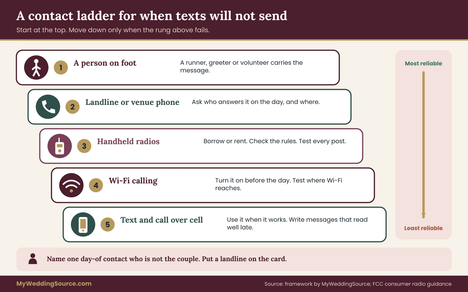
- A person on foot. The most reliable method is to send someone. A runner, a greeter or a volunteer can carry a message across a field faster than a failing text.
- A landline or venue phone. Ask whether the venue has a landline and who answers it. A guest who reaches a house phone can often leave a message with a person who can find the right person.
- Radios. Handheld radios, borrowed from the venue or rented, are a standard solution for large properties. Check the rules for the radio type and any license requirement, which the Federal Communications Commission explains for consumer radio services, and test that they reach every working position. Radios also need a quiet channel and someone to monitor it.
- Wi-Fi calling and messaging over Wi-Fi. If the venue has Wi-Fi in some areas, phones that support Wi-Fi calling can place calls and send texts over that network. Ask each key person to check that the feature is turned on before the wedding, and test it at the venue. Wi-Fi must reach the places people will actually stand.
- Text and call over cell service. Use it when it works, but do not rely on it. Messages may arrive late, so write them to make sense when delayed: “Cars are parking in the top field” is better than “Where are you now?”
Keep the planner reachable by more than one route
If you have a planner, give them the contact ladder in writing. Make sure they know where on the property signal is best, and have them check in with the venue manager at set times. A good habit is a standing check-in every thirty minutes at a known spot, so people know where to find them even when phones fail.
Agree on a late-guest rule
Guests will be late, and with unreliable cell service you will not hear about it. Decide in advance what happens to a ceremony start time when guests are missing. Some couples build in a short buffer before the ceremony, a cushion that lets a few late cars slip in without anyone noticing. Some assign an usher at the entrance to quietly seat latecomers. The wedding vendor timeline guide shows how to build buffers into a schedule without leaving vendors idle. Decide on a firm limit with the officiant and the photographer, so nobody is guessing when to start.
Use the cocktail hour as a buffer
If guests arrive over a wide window, the cocktail hour can absorb some of the uncertainty. Guests who arrive between the ceremony and the reception still have a place to land. The guide to the wedding cocktail hour explains how to plan that stretch so late arrivals and early arrivals have something to do. It is not a substitute for a good arrival plan, but it keeps the day forgiving.
Write a short script for the contact person
When a lost guest finally reaches someone, the call is brief and stressful. Give the contact person a script: ask where the guest is, what they can see, which landmark they passed last, and then give one step. “Tell me the last thing you passed. Okay, you are about five minutes from the gate. Turn around at the next driveway and go back to the stone wall.” One step at a time keeps the guest calm and moving.
Safety, weather and emergencies at a venue with limited cell service
Unreliable cell service is an inconvenience on an ordinary day. It becomes a safety question when something goes wrong. This section does not give rules or guarantees. It lists the questions to ask the people who are responsible for the property and for emergency planning, and it points to official sources for the rest.
Ask the venue for its emergency plan, and read it
A venue that regularly hosts events should have a plan for medical emergencies, severe weather, fire and power loss, and should be able to tell you who is in charge and how they call for help. Ask these questions in plain language:
- How does staff call for help if cell service is down? Is there a landline, a radio or a satellite device?
- What is the street address that emergency responders use for the property, and does it match the guest entrance? Rural properties sometimes have several access points, and responders need the right one.
- Who meets an ambulance at the gate and leads it to the right place?
- Where do guests shelter if severe weather arrives, and who decides when to move?
- Who is responsible for opening gates, and how quickly can that happen?
Write down the answers and share them with your coordinator. Do not try to design an evacuation or occupancy plan yourself. Capacity, exits and emergency procedures are matters for the venue operator and local officials, and no guide can set them for your site.
Calling for help with weak cell service
Emergency calls in the United States use 911, and a phone may be able to place an emergency call over a network other than the user’s own carrier in some conditions. Coverage and features differ by phone, carrier and location, and text-to-911 is not available everywhere.
The federal 911 information site explains what is available and what to do, and it is listed in the sources. The simple practical point is this: do not assume that any phone will work at any spot on the property. Ask the venue where the best place to call from is and make sure staff and the couple’s helpers know it. Tell your coordinator and the venue manager the spots where a call from a mobile phone is most likely to go through, based on your survey.
Weather alerts need a signal too
Many people rely on phone alerts for severe weather. In a place with poor cell service, those alerts may arrive late or not at all. The National Weather Service publishes safety guidance on its site, including how to prepare for lightning, flooding, high winds and heat, and it describes NOAA Weather Radio as a way to receive alerts without a phone. The link appears in the sources.
For an outdoor wedding in a cell service dead zone, consider asking the venue whether they monitor a weather radio or a forecast source, who decides to pause an event, and how they tell guests. Look at the forecast the day before and the morning of, and decide in advance who will make the call.
Heat, cold and dark
A guest stranded on a rural road in a long dress or a suit, in hot or cold weather, can be uncomfortable or at risk. Add a short line to the card for the unexpected: “If you have a breakdown, stay with your vehicle, turn on your hazard lights and call the venue number.” Make sure the venue or a helper knows which roads guests use, so a car that has not arrived can be found. A simple check-in system at the gate, with a rough count of arrivals, helps hosts see whether a car is missing.
Do not publish safety guarantees
Be careful what you promise. Do not tell guests that a route is safe, that a shuttle will arrive on time or that emergency help is a specific number of minutes away. You cannot know those things. Say what you do know: the venue has limited cell service, here is the landline, here is the card, and here is a person at the gate. Where official facts matter, link to the agency or ask the venue to confirm.
Accessibility and the cell service dead zone
A route that is fine for a fit, young guest may not work for a guest who uses a wheelchair, a walker or a cane, or for someone with low vision. The survey should include an accessible route, with its own landmarks, distance and surface notes.
Ask about the surface of the path (gravel, grass, boards), slope, lighting and the location of accessible parking and drop-off. The ADA information site explains accessibility requirements for facilities, and the guide on accessible wedding venue red flags lists warning signs to look for when evaluating a venue. For directions, include a separate short card or line for the accessible route, and tell the greeter and the shuttle driver about it, so no guest has to ask in front of others.
A worked example: a hillside venue with no cell service
The following example is invented. It shows how the pieces of this guide fit together for one imaginary wedding, and none of the details come from a real event or a real place.
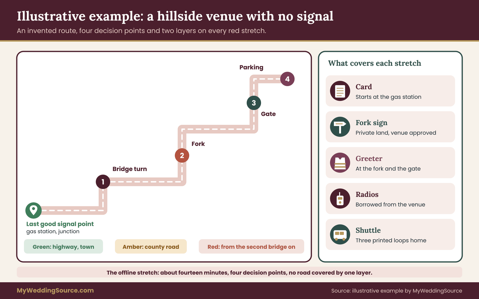
Priya and Marcus are planning a late-afternoon wedding at a hillside venue, forty minutes from the nearest city and about twelve minutes past the last town. They have one hundred and ten guests, a mix of local friends, relatives from out of state and a group of older relatives who will drive in together.
The survey
On a Thursday afternoon, Priya’s cousin Dana, who lives nearby, drives the route with two phones on different carriers. She uses the car’s trip meter and writes notes. The results are clear. The highway and the last town are green. The county road turns amber about two miles past the town, and goes red for both phones at the second bridge, about four miles in. The gate, the parking field and the lawn are all red. The only green spot on the property is beside the venue office, where a Wi-Fi network reaches a small porch.
The last good signal point is the gas station at the junction of the county road and the highway, which is easy to name and easy to see. From there, the offline stretch is about fourteen minutes. There are four decision points: the turn at the bridge, a fork where a gravel lane splits toward a neighbor’s farm stand, the gate, and the parking field split between a main and an overflow area. The most likely wrong turn is the farm stand lane, because it has a bigger sign than the venue does.
The layers
Dana and the couple apply the coverage rule. Every red leg needs two layers. They write the final-mile card, starting at the gas station, with a distance at each turn, a note that the farm stand means “turn around,” and the venue landline number, which the manager confirms is answered all afternoon. They include a screenshot-friendly version for the guest message, and they mail printed cards to the older relatives with the invitation, since that group is least likely to download maps.
For the route layer, the venue agrees to hang a banner at the gate and to place two small directional signs at the fork, on private land. They do not place anything at the highway, because it is a public road and the rules are unclear. For the people layer, Marcus’s brother and a friend stand at the fork and the gate during the arrival hour, with printed cards, water and radios borrowed from the venue.
The message schedule
They put the card on the wedding website six weeks out, with the offline map reminder. A week before the wedding they send a short message with the arrival window and the card. The night before, they send a screenshot-ready image with the venue number. The hotel front desk receives forty printed cards.
The day
Guests drive in over about an hour. Most follow the card; a few arrive from the wrong side after their map app picked a road with a locked gate, and the brother at the fork waves them toward the right route. One car stops at the farm stand, and the owner points them back. The contact ladder holds: Dana stays near the venue office, where Wi-Fi works, and everyone else uses radios.
At the end of the evening, the couple’s transportation plan matters. Because rideshare drivers rarely accept trips to the venue, they have booked a shuttle that makes three loops to the hotel, at times printed on a sign at the gate and on the card. The shuttle driver has a printed card too.
What the example shows
The couple did not eliminate the cell service problem. They narrowed it to fourteen minutes of road and four decision points, and then covered each with at least two layers. They also decided early who would be the contact, and it was not the couple. The effort was a few hours of survey, a one-page card, some printing and two volunteers. That level of effort is realistic for most couples, and it is more useful than any app.
Special cases that change the plan
The basic method works for most weddings. A few situations call for adjustments.
Older guests and guests without smartphones
Some of your most important guests may have no smartphone, or have one they do not use for maps. For them, a printed card and a person are the real plan. Ask a relative or friend to be the contact for each group, and mail the card early. If a guest is traveling alone, ask whether someone can ride with them or lead the way. Avoid asking these guests to scan a code or open a link; they may not be able to.
International and out-of-region guests
Guests from abroad may have no data on their phones, may be driving an unfamiliar rental car and may not know local road conventions. Offer a card that uses clear landmarks and distances in both miles and kilometers, if you expect it, and suggest they rely on the hotel’s printed copy. If your guests will use rental cars, remember that car navigation units use their own maps, so the card is the main plan. Pre-arranged shuttles from the airport or hotel are especially helpful for this group.
Two or more locations
If the ceremony, the reception and the hotel are in different places, each leg of the day is its own route. Survey each, write a card for each and decide where the last good signal point lies on each. Put a short transition note on the program: “Cell service is limited at the reception site. Directions are on the back of this card.” A guest leaving a ceremony from a ceremony site with poor cell service to a reception site with the same problem needs the second card in hand before they leave the first.
Destination weddings and remote lodging
In destination settings, the problem is often not the venue but the whole region. Ask the hotel or local host about local coverage, which carriers work, and whether guests should buy a local SIM or plan on Wi-Fi only. Provide a printed card at the hotel desk, and ask the local coordinator or a hired driver to meet arriving guests. Guests who will rely on hotel Wi-Fi should know in advance where that network stops.
Winter, rain and night
Weather changes how a route behaves. Gravel roads turn to mud, fields close, and signs are hard to read in rain. Ask the venue for a backup route and parking plan for wet or snowy conditions, and write it as a short alternate section of the card. Keep a stack of printed cards in a plastic sleeve or zip bag in case of rain. Check the forecast the day before, and tell guests early if the plan changes.
The day-before and day-of kit for a venue with no cell service
A good plan for a venue with limited cell service is easier to run when everything physical is in one place. Gather a small kit the day before and hand it to the coordinator, the day-of contact or a trusted helper. The kit is not complicated, and each item addresses a failure described earlier.
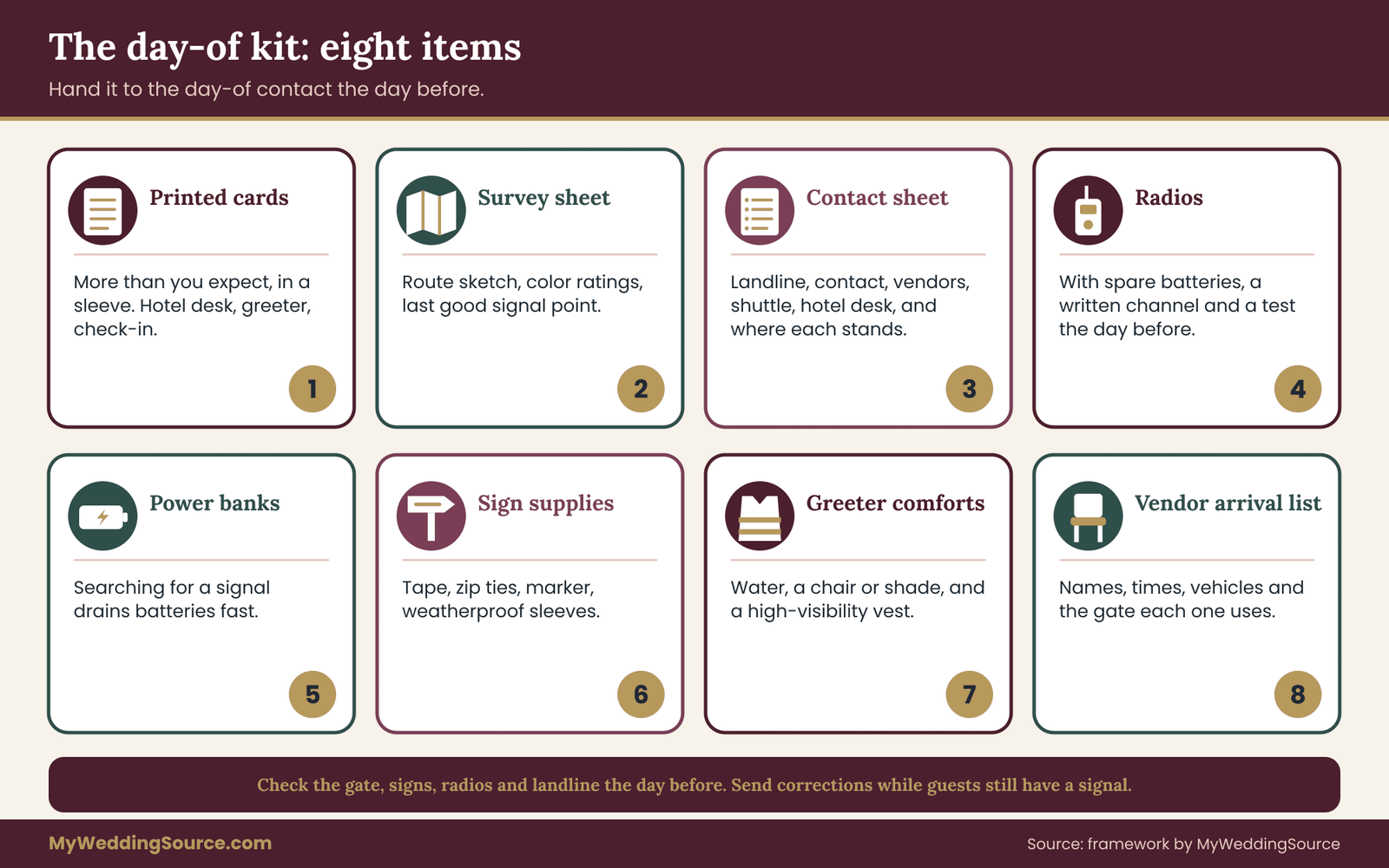
Printed final-mile cards. More than you expect, in a folder or sleeve. Put a stack at the hotel desk, at the greeter’s post and at the check-in table, and keep a few in the couple’s family cars.
The one-page survey sheet. The route sketch, the color ratings, the last good signal point and the decision points. It lets a new helper understand the situation in a minute.
A contact sheet. The venue landline, the day-of contact, the coordinator, the vendors, the shuttle company and the hotel desk, with the place each person will be standing, because a number is only useful if you know where to find the person.
Radios and spare batteries. If you are using them, with a written channel and the names of the people who carry them. Test them at the venue the day before.
A charged power bank or two. Phones used as flashlights, maps and cameras drain quickly, and a venue with poor cell service makes phones work harder searching for a signal, which uses more battery.
Signs, tape, zip ties and a marker. For last-minute changes, such as a closed road or a gate that moves. Include a few weatherproof sleeves.
Water, a chair and a high-visibility vest for each greeter. People who work outside for an hour or two need basic comfort to do the job well.
A printed list of expected vendor arrivals. With names, times, vehicle descriptions and the gate to use, so the person at the entrance can recognize and direct them.
The day-before walk-through
If you can, make a short final visit or call the day before. Confirm that the gate will be open, that signs are in place, that the radios work and that the landline will be answered. Check the road for closures, construction or events that might change the route. Many county and state transportation agencies publish road closure information, and the venue manager may know of local events. If anything changed, update the card and send a short correction by email and text while guests still have a signal.
The day-of sequence
Arrange the morning so that the arrival plan is in place well before the first guest. A rough order is: helpers arrive and get briefed; signs and banners are placed; radios are tested; the greeter takes their post; the gate staff confirm the opening time; the day-of contact does a final check with the venue manager. The coordinator then keeps a loose count of arrivals and checks in with the greeter at set times. If the ceremony start has a buffer, a quiet signal from the greeter (a wave at the radio, a short call to the contact) tells the coordinator when most guests are in.
Common mistakes and limits when planning for poor cell service
Most problems fall into a small number of patterns, and knowing them in advance is the cheapest protection.
Relying on a coverage map instead of a walk. A map says what is likely, not what is true at your gate. The signal walk is the fix.
Sending directions only by link. A link needs data. Send the card as an image and as text, and print it.
Starting directions at the wrong place. A card that begins at the couple’s home town leaves the guest guessing at the moment they need help. Begin at the last good signal point.
Skipping the wrong-turn warning. Most wrong turns are predictable, and naming them saves time. If your card never says “if you see X, turn around,” look again.
Giving the couple’s number as the lost-guest contact. The couple is busy and may have no cell service. Name another person, and use a landline.
Forgetting the return trip. The end of the night has its own signal problems, its own darkness and its own transportation needs. Survey it, and print the departure times.
Trusting one layer. One card, one sign or one volunteer will fail someday. Cover each red leg with two layers.
Placing signs without permission. A sign on a public road or a neighbor’s land can cause a dispute, a fine or a safety problem. Ask first, and take signs down.
Over-writing the card. A long card with history, schedule and parking rules is not read. Give it one job.
Skipping the test. A card that has never been followed by a stranger is a draft. Ride along with someone once, and fix what slows them.
Treating guests who do not read as a failure. Some will not read anything. Build the route and the people layers so those guests still arrive.
Limits of this guide and what to confirm yourself
No guide can tell you what the signal is at your gate, which roads are open or what your venue allows. Several things should come from the people responsible for them, and you should confirm them in writing when you can.
Cell service coverage. Your own survey is the evidence. Coverage differs by carrier, season, time of day and crowd size, and it changes as carriers add or remove equipment. A test from six months ago may not be accurate on the wedding day, so repeat it close to the date if you can.
Property rules. The venue owns the rules about signs, gates, vehicles, radios and shuttles. Ask for their rules in writing, and ask whether they have a standard arrival sheet.
Road and parking rules. Local governments and transportation agencies decide what may be placed near a public road, whether a person may direct traffic and whether permits are needed. Contact the local office or the venue’s own contact for the current rules.
Emergency and weather procedures. The venue operator and local emergency officials decide capacity, evacuation and shelter. The National Weather Service and the 911 information site provide public safety guidance. Nothing in this article replaces those sources or sets a safe number, time or distance.
Radios and equipment. The Federal Communications Commission explains the rules for consumer radio services, and equipment rules change. Check current requirements, or rent radios from a vendor who explains them.
Vendor and contract terms. If you ask a vendor, such as a shuttle company, to provide a service tied to arrival, put the details in the contract. The guide to due diligence on wedding vendors explains what to ask a vendor before you sign, including who is responsible when something goes wrong on the road.
Your own assumptions. Separate what you tested from what you assume. “Cell service works at the gate” is a result if you tested it with three phones and an assumption if you looked at a map. Label them on the survey sheet so the people who use it know which is which.
Your next steps
Pick one afternoon in the next few weeks and do the signal walk. Bring two or three phones on different carriers, a notebook and a friend. Find the last good signal point, mark the decision points and rate each leg green, amber or red.
Then write the final-mile card, test it with a stranger and send it to guests at the four moments in the schedule, once as an image and once as text. Print more copies than you think you need. Cover every red leg with two layers, name a day-of contact who is not the couple, and set up a contact ladder that does not depend on texting. If you are unsure which parts of your route are public or private, or what the venue allows, ask the venue manager and the local authorities now rather than the week of the wedding.
When the work is finished, the problem of cell service shrinks to a few minutes of road, and every guest has a way to get through them.
FAQ
How do I give directions to a wedding venue that has no cell service?
Start the directions at the last place where cell service works, such as a gas station or crossroads, and write short numbered steps with distances and visible landmarks. Name the likely wrong turn. Send the directions as an image and as text, print copies for the invitation and hotel, and add a person or a sign at each fork.
How can I find out whether my venue has cell service?
Visit the route with two or three phones on different carriers and test each leg. Check whether a map tile loads, a text sends and a call connects, rather than counting bars. Use the FCC National Broadband Map only as a first guess. Ask the venue which carriers work best and where the dead spots are, then repeat the test close to the date.
Should I tell guests to download offline maps?
Yes, as one layer, not the only one. Ask guests to download the area on Wi-Fi in the week before the trip, and link to the official instructions from Google or Apple. Some guests will forget, some have older phones, and rental cars use their own maps. So add a printed card and a screenshot as backups.
Will GPS work at a venue with no cell service?
Usually the phone can still find its position by satellite, because GPS does not depend on cell service. The problem is the map underneath, which needs data unless it was downloaded earlier. A guest may see their location dot on a blank screen. That is why an offline map, a saved pin and a printed card matter.
What should the printed fallback include?
Include a short numbered list of steps starting at a named landmark, distances, the wrong-turn warning, the gate name and opening time, the venue landline and the parking instructions. Use large, high-contrast type on matte paper. Leave out the history, the schedule and the registry. A small sketch map is optional and should match the words on the card.
How do guests request rideshares if there is no cell service?
They may not be able to, so do not count on it. Choose a pickup point where your survey found reliable service, mark it with a sign and tell guests early. Better still, book a shuttle or car service with fixed times and a printed route. Ask the venue whether rideshare drivers are allowed on the property at all.
Who should guests contact if they get lost?
Name a day-of contact who is not the couple, such as a coordinator or a relative, and give a landline or a number that will be answered from a place with signal. Station a greeter at the turnoff with a printed card. Ask the contact to guide lost guests one step at a time, starting with the last landmark the guest passed.
Is it safe to host a wedding where cell service is poor?
Many weddings are held in such places, but safety is a question for the venue and local officials, not for any guide. Ask the venue how staff call for help, which address responders use, where guests shelter in bad weather and who is in charge. Check the National Weather Service for weather guidance and the 911 information site for emergency calling.
Sources
- Weather safety, National Weather Service
- FCC National Broadband Map, Federal Communications Commission
- Federal Communications Commission
- Download areas to use offline, Google Maps Help
- Apple Support, Maps
- 911 information for the public, 911.gov
- Manual on Uniform Traffic Control Devices, Federal Highway Administration
- Americans with Disabilities Act information, U.S. Department of Justice
- Ready.gov, preparing for emergencies, Federal Emergency Management Agency